
20
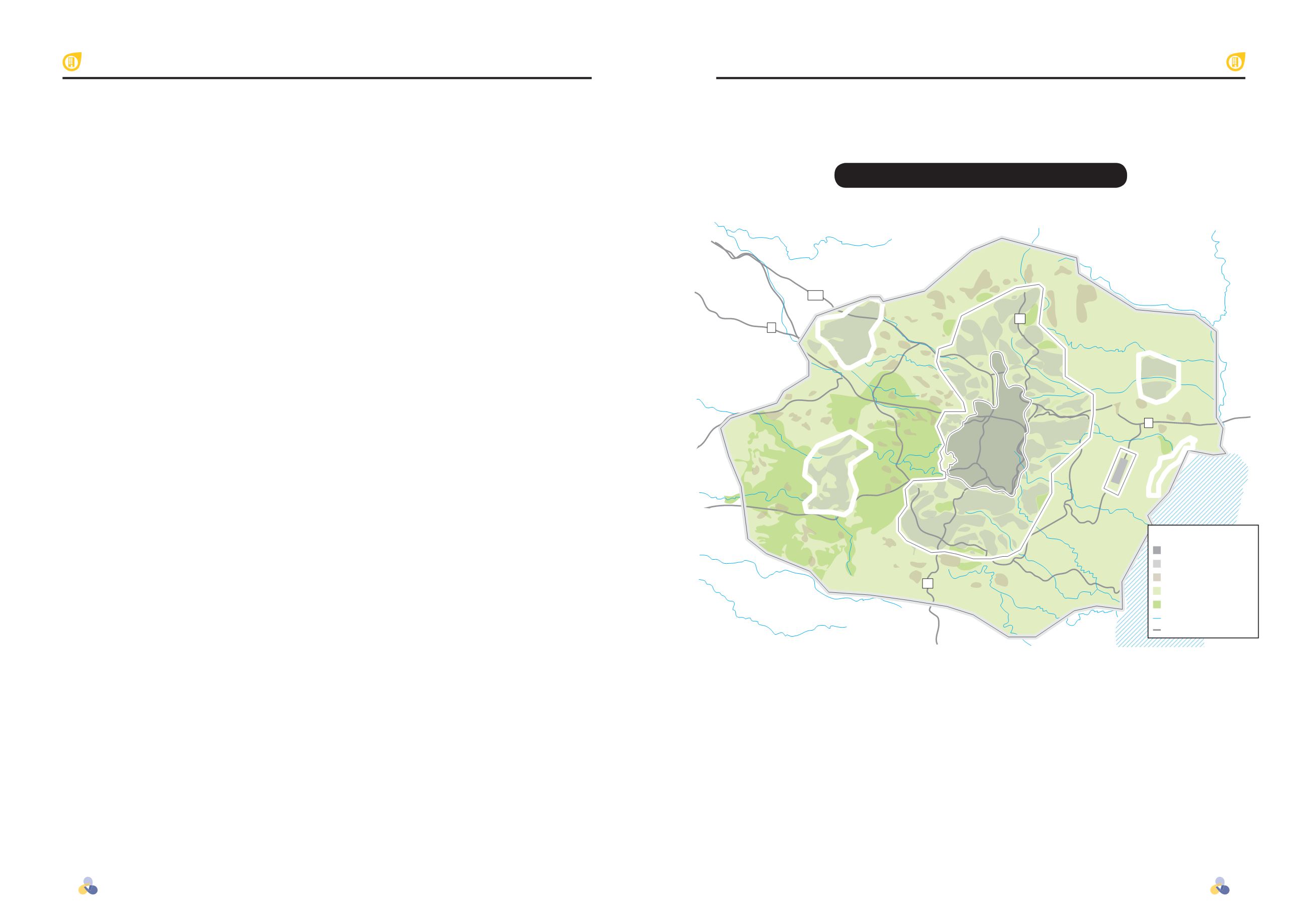
The Metropolitan Jerusalem Master Plan
The Metropolitan Jerusalem Master Plan
21
443
60
60
1
1
Jericho
Ramallah
Modiin
Giv’at Ze’ev
Beit
Shemesh
Maaleh Adumim
City of
Jerusalem
Bethlehem
Gush Etzion
Judean Desert
Airport
Dead Sea
Hotels
Dead Sea
Internal area for buiding
Area for building – other
Area for rural building
Clear view area
Parks/forests
River
Main road
Legend
Planned Circles of Metropolitan Jerusalem
construction is possible, and indeed, it is in
this area that the city of Maaleh Adumim is
built – one of Jerusalem’s most important
suburbs today.
Thus, the metropolitan Jerusalem region
is defined in three concentric circles: the city
of Jerusalem lies in the innermost circle –
the area which more or less comprises the
municipal boundaries of Jerusalem today;
the second circle is comprised of the city’s
immediate suburbs, including municipalities
and regional councils of Maaleh Adumim,
Gush Etzion, Abu Dis, Giv’at Ze’ev,
Bethlehem, Mivaserret Zion, and Ramallah,
as well as rural areas such as Gush Etzion and
Gush Elon; and the third circle is the green,
open-area forested corridor, the preservation
of which is imperative to the maintaining of a
healthy ecological environment for Jerusalem.
Understanding the urban functions of each
circle is necessary as a basis for any future
planning of the metropolis.
//
Borders of Metropolitan Jerusalem
The great innovation of the Jerusalem 5800 Plan is in its approach to
Jerusalem, not as a city unto itself, but as a metropolis that includes a large
peripheral region, planned as one body.
The Jerusalem 5800 Plan offers a vision
for the development of metropolitan
Jerusalem – a term that stretches beyond
the municipal boundaries of Jerusalem.
As the city itself isn’t expected to grow
significantly over the coming decades,
the development in question is that
of a greater geographical area, which
even today comprises the city’s larger
metropolitan region.
This metropolitan region, built around
the urban makeup of Jerusalem, can
be defined both in economic and in
transportation terms. Economically, the
metropolitan region includes the areas
for which Jerusalem is the natural focal
point for commerce and industry – the
areas for which the city of Jerusalem is
a commercial focal point. In terms of
transportation, the metropolis is defined as
the geographical region from which daily
commuter traffic both for work and other
reasons is centered on Jerusalem – the
areas from which most of the residents
commute to Jerusalem on a daily basis.
According to the Ministry of Interior’s
most recent definition, the Jerusalem
district runs to the Jordan river and the
Dead Sea in the east, Beit Shemesh in the
west, Ofra and Beit El in the north, and
Gush Etzion in the south. This region,
at the center of which Jerusalem resides,
with its surrounding suburbs and villages,
relates to Jerusalem as the central city of
the district.
The boundaries of metropolitan
Jerusalem, and the possibility for
construction and development therein,
are defined by geographical and ecological
characteristics. The Jerusalem mountains
are an important link in the open-space
continuum between the Binyamin
mountains of the north and the Hebron
mountains in the south – a continuum
of great ecological significance and
a vital corridor for wildlife and plant
preservation. In accordance with the
geographical makeup, metropolitan
Jerusalem is limited in terms of
possibilities for expansion westward,
and is close to reaching full capacity
for such expansion in this direction.
Another ecological corridor exists east
of Jerusalem, running from north to
south by the fault cliff over the Dead Sea
and the back slopes of the mountains
approaching the Jordan Valley and the
Dead Sea. Between this ecological corridor
and Jerusalem there is an area in which
In terms of economy,
metropolitan Jerusalem
is defined as the city’s
natural focal point for
business.
In terms of transportation
– as the geographical
region in which traffic is
intense daily.
Jerusalem Rebuilt
Jerusalem Rebuilt


