


 64-65 / 108

64
The Metropolitan Jerusalem Master Plan
The Metropolitan Jerusalem Master Plan
65
443
”
Ben Gurion
Beit
Shemesh
Jericho
Ramallah
Bethlehem
Maaleh Adumim
Airport
Dead Sea
Hotel Region
Dead Sea
Route 60
375
West 1
East 1
Junction 60
Latrun Junction
HaElah Junction
Mateh Yehuda
Regional Council
Gush Etzion Junction
Gush Etzion
Regional Council
Almog Junction
Megillot
Regional Council
Shifra Junction
Binyamin
Regional Council
Binyamin Regional Council
Gas Station
Modi'in
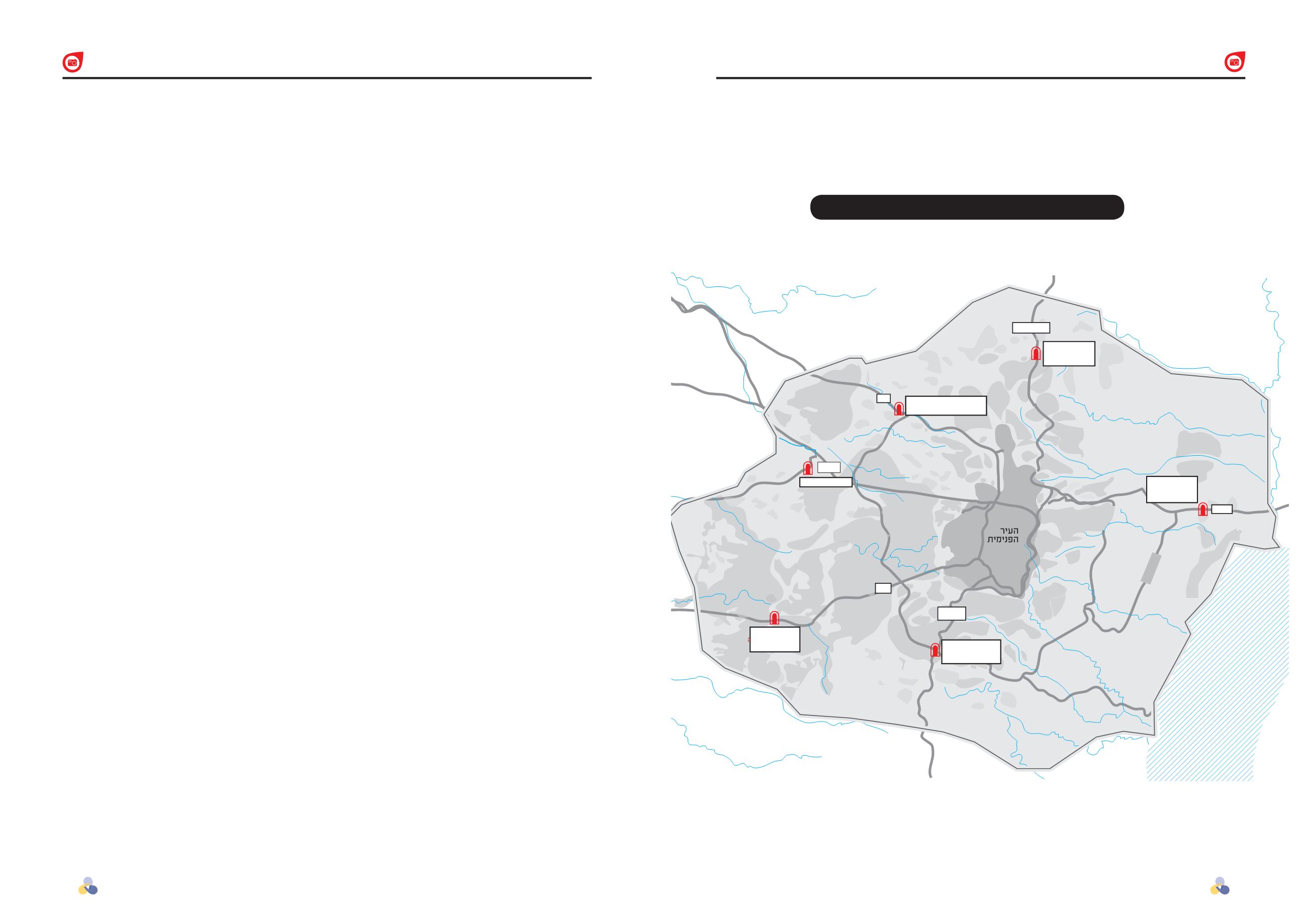
Planned Sites for Jerusalem Gates Locations
//
Jerusalem Gates
The metropolitan Jerusalem borders need markers and signs in order
to give these borders presence for the visitor and local residents.
The “Jerusalem Gates” project is meant to serve these purposes.
In order to increase awareness of the
metropolitan region of Jerusalem and to
shape its borders in the public and national
consciousness, the Jerusalem 5800 team
has initiated the Jerusalem Gates project.
The concept behind the project is to
create compounds within the metropolitan
borders, which will signify these borders
and serve as entrances for tourist intake
and direction.
Features of the Project
At the end of 2014, the Central Bureau
of Statistics defined the metropolitan
Jerusalem region. The borders defined
were identical to those defined by the
Jerusalem 5800 team. The Jerusalem
Gates project will be planned and carried
out with environmental, tourism, and
nature authorities, such as the Society for
the Protection of Nature, the National
Parks Authority, the Jewish National
Fund, the Ministry of Tourism, regional
councils, and the Jerusalem Municipality.
During project implementation, along
the main roads leading to metropolitan
Jerusalem, adjacent to points of entry
into the metropolis, compounds with
several components will be created. A
sign on the main road will direct travelers
to the areas. The compounds should be
based on rest and service stops along
the road, such as gas stations, in order to
keep costs down and planning processes
short. Each of these areas will contain
a gas station, a convenience store with
food and beverages, and a rest area.
Tourist information and equipment will be
available or for purchase. Additionally, each
of these “gates” should include a visitor’s
center unique to the project, which will
provide the visitor with information about
metropolitan Jerusalem in its entirety and
the location of the gate specifically.
Further, at each of the areas, there will
be additional components. Though it will
not be possible to develop all of them
at every station, the best will be done to
develop as many as possible:
►►
Ample parking
►►
Green open areas – a rest and lodging
area which takes on the character of the
gate’s location, offering unstructured
experience of the surroundings
►►
Stores or a market selling locally made
products
►►
A visitor’s center
►►
Varied restaurants
►►
Starting points for hikes and biking and
jeep tours
►►
Road services (a garage)
►►
A motel
►►
A Pilgrimage registration point
The Project’s Purpose
The Jerusalem Gates project has several
purposes, each supporting the other:
►►
Establishing a physical, visual, and
symbolic network of gates to serve
as specific markers along the main
roads leading to Jerusalem, to be
spread out along the circumference of
the metropolitan region, marking its
borders.
►►
The gate compound will create public
awareness among all sectors – local
residents and guests – of the fact
that the metropolitan region exists as
such. This awareness will contribute
Hotels and Tourism
Hotels and Tourism